05/03/2026-11/03/2026
[1] OpenSeaMap-vector | © k-yle | map data © OpenStreetMap Contributors.
Mapping
- AndreaDp27 has proposed a tagging scheme to map officially designated civil protection areas. Voting opened on 9 March 2026 and will close on 23 March 2026.
Community
- At the recent State of the Map Ben Hur Pintor delivered a presentation titled ‘Awesome (OSM) Games’, highlighting a range of games that make use of OpenStreetMap data, though they are not necessarily designed to contribute back to the mapping platform.
- Derlamaer has proposed a new OpenStreetMap tag for detector-operated pedestrian signals (
detector_operated=*). - Mikel Maron vibe coded an OpenStreetMap – Overture Maps conflation tool.
- Natfoot has proposed the
railway=trailtag to mark bike routes along rail trails. - Rene78 noticed that it is possible to politely ask ChatGPT to generate a proper
opening_hourstag. - Simon Poole outlined several challenges faced by the Swiss OpenStreetMap community while they attempted to import municipal boundary data from Switzerland’s federal GIS department into OpenStreetMap.
- In response to Overture Maps‘ recent attempt to make their Global Entity Reference System (GERS) an Open Geospatial Consortium standard, Simon Poole argued that OSM object IDs also suffice as an alternative to GERS. Meanwhile, in a separate diary entry, rphyrin shared the same sentiment.
- Simon Poole reported that the Vespucci app might run into problems on older Android devices due to root certificate expiration, because older versions of Android only update certificates during full system updates. He suggested that users manually install the certificate as a temporary workaround for the issue, since Vespucci is currently not prepackaged with the full set of certificates, all while acknowledging that this method could increase user friction to an unacceptable level.
- Pascal Neis analysed the recently introduced company and location fields in OpenStreetMap user profiles, concluding that his HDYC profiles provide more reliable indicators because they are derived directly from collected and analysed contribution data, rather than from self-declared free-text profile information.
Local chapter news
- Jochen Topf reported
 ► that FOSSGIS e.V. has received funding from the German Foundation for Engagement and Volunteering to carry out an OpenStreetMap training programme.
 ►
►
Maps
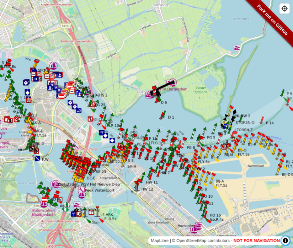
- [1] k-yle has developed OpenSeaMap-vector, a rewrite of OpenSeaMap, using vector tiles instead of raster tiles.
Open Data
- François Lacombe has compared several analytical frameworks used to examine data-sharing practices in France.
 several analytical frameworks used to examine data-sharing practices in France.
Software
- HeiGIT reported that they have developed an open dataset platform called OpenAccessLens that visualises physical access to education and healthcare services worldwide. It shows how far people are from the nearest schools and hospitals, expressed in travel time or distance.
- The team at the OSM Website shared a recap of their latest work, including progress with the transition to MapLibre and a number of fixes to user experience.
Programming
- Altsybeyev explained how MapMagic developed its own topographic maps by combining OSM data and the Mapterhorn digital elevation model.
 how
how Releases
- CoMaps has released version 2026.03.09, adding support for Type 1 combo EV chargers, displaying amounts charged for use of facilities as well as the population of cities. Further, it added and improved support for POI types such as entertainment attractions and water shops.
- Bastian Greshake Tzovaras has published version 0.4.0 of the CoMaps map-distributor Python CLI tool. It improves the management of downloads and partial downloads.
- Christoph Hormann announced that the OpenStreetMap Carto maintainers have prepared a new major release of the OpenStreetMap Carto stylesheet.
Did you know that …
- … recently QGIS had been using the OpenStreetMap tile server more than OpenStreetMap.org itself? Some QGIS plugins could be used as OSM tile bulk downloaders and might be responsible for this issue, but a safeguard has recently been added to prevent such things.
OSM in the media
- Falk Steiner, of Heise, argued ► that OpenStreetMap bears partial blame for the recent cable bridge fire that caused a blackout across parts of Southwest Berlin, citing the platform’s open data practices as having contributed to the exposure of critical infrastructure location data that could be used for sabotage purposes.
- Emhraim, of GNU/Linux.ch, has showcased ► some mobile apps for editing OpenStreetMap: CoMaps and StreetComplete.
- In a recent interview in Basta!, a French independent online news outlet, Jérôme Hergueux, a researcher at the Centre national de la recherche scientifique specialising in social networks, claimed ► that the OpenStreetMap project is ‘now largely dormant’ because another for-profit navigation app, which also provides map services, discourages new contributors from joining the community.
Other “geo” things
- Researchers from the Institute of Historical Research, University of London have built ‘Layers of London’, a free historic map of London where users can contribute stories, memories, and histories to create a social history resource about their locality.
- Historian Ivan Malara accidentally discovered Galileo Galilei’s handwritten annotation in a copy of Ptolemy’s The Almagest in Italy’s National Central Library of Florence.
- Isaac Corley and Caleb Robinson have started a blog GeoSpatial ML, which offers articles on machine learning, remote sensing, and other topics. You can follow them using their RSS channel or on their Substack. Their latest post was titled ‘Training a Water Segmentation Model with TorchGeo’.
- Pierre Sauche commented ► on the Le Rize ► mémoires, cultures, échanges, which includes an interactive web map where you click to view historic photos and other information. The project has the support of IGN, the French geospatial agency.
- The University of Zaragoza led ► the development of an online cartographic viewer , as part of the FirePaths Project for forest fire risk analysis. It uses free and open software and OGC standards, including OpenStreetMap as a base map.
- Katharina Seeger and Philip Minderhoud warn that the sea level is much higher than assumed in most coastal hazard assessments. In an article published in Nature, they argue that nearly 99% of evaluated assessment reports are affected by an incorrect methodology, which assumes a mean sea level based on global geoid models, not using precise techniques (such as using airborne Lidar) and not considering the coastal elevation.
 ►
►Upcoming Events
| Country | Where | Venue | What | When |
|---|---|---|---|---|
| 2026-03-12 – 2026-03-13 | ||||
 | Magrathea Laboratories Chaos Computer Club Fulda | OSM-Tools: Wenn die Welt zur Spielwiese wird | 2026-03-13 | |
 | Leuven | Romaanse Poort | Camera’s in kaart brengen | 2026-03-14 |
 | Online | A Mapathon to enrich participatory mapping of short supply chains around the Tokikoa label in the Basque Country | 2026-03-17 | |
 | Zaragoza | Online | Mappy Hour OSM España | 2026-03-17 |
| Missing Maps London: (Online) Mid-Month Mapathon [eng] | 2026-03-17 | |||
| Lyon | Tubà | Réunion du groupe local de Lyon | 2026-03-17 |
| Bonn | Dotty’s | 198. OSM-Stammtisch Bonn | 2026-03-17 |
| Online | Lüneburger Mappertreffen (online) | 2026-03-17 | |
| MJC de Vienne | Rencontre des contributeurs de Vienne (38) | 2026-03-18 | |
| Online Mapathon – Ärzte ohne Grenzen | 2026-03-18 | |||
 | Stainach-Pürgg | Online | 20. Österreichischer OSM-Stammtisch (online) | 2026-03-18 |
| Gent | Tramzwart, KASK | Camera’s in kaart brengen | 2026-03-19 |
| Heidelberg | DEZERNAT#16 | Rhein-Neckar OSM Treffen // Intro iD-Editor | 2026-03-19 |
| OSMF Engineering Working Group meeting | 2026-03-20 | |||
 | Olomouc | Přírodovědecká fakulta Univerzity Palackého | Missing Maps Day Olomouc 2026 | 2026-03-21 |
| Domplatz Fulda | Frühlingsmapping 2026 | 2026-03-22 | |
| Missing Maps : Mapathon en ligne – CartONG [fr] | 2026-03-23 | |||
| Stadtgebiet Bremen | Online und im Hackerspace Bremen | Bremer Mappertreffen | 2026-03-23 |
| Pôle Numérique Brest Iroise | Rencontre OpenStreetMap et Territoires | 2026-03-24 | |
| Göttingen | Uni Göttingen | FOSSGIS-Konferenz 2026 | 2026-03-24 – 2026-03-27 |
 | Derby | The Brunswick, Railway Terrace, Derby | East Midlands pub meet-up | 2026-03-24 |
| Düsseldorf | Online bei https://meet.jit.si/OSM-DUS-2026 | Düsseldorfer OpenStreetMap-Treffen (online) | 2026-03-27 |
| Chemnitz | Neues Hörsaalgebäude, TU Chemnitz | Chemnitzer Linux-Tage 2026 | 2026-03-28 – 2026-03-29 |
| Göttingen | Uni Göttingen, Fakultät für Geowissenschaften | FOSSGIS 2026 – OSM-Samstag | 2026-03-28 |
| Local Chapters & Communities Congress 2026 | 2026-03-28 | |||
| Vélo Utile | rencontre OSM | 2026-03-28 | |
 | Mira-Bhayander | DBT Café, Mira Road | OSM Mumbai Mapping Party No.8 (Western Line – North) | 2026-03-28 |
| Hannover | Kuriosum | OSM-Stammtisch Hannover | 2026-03-30 |
Note:
If you like to see your event here, please put it into the OSM calendar. Only data which is there, will appear in weeklyOSM.
This weeklyOSM was produced by MarcoR, MatthiasMatthias, PierZen, Raquel IVIDES DATA, Strubbl, Andrew Davidson, barefootstache, derFred, izen57, s8321414.
We welcome link suggestions for the next issue via this form and look forward to your contributions.
Wo argumentiert Falk Steiner, dass OSM eine Mitschuld am Brand der Kabelbrücke trägt? Vielmehr wird OSM lediglich in indirekter Rede erwähnt, Steiner stellt also nur die Position von Teilen der Berliner Landespolitik dar.